Royal Navy Rifle Range
Coburg Peninsula
Coburg Peninsula
By Jack Bates
The Royal Navy built and operated a rifle range on the Esquimalt Lagoon spit (Coburg Peninsula), co-incidental with Esquimalt becoming the Pacific Station for the British fleet in 1865. The Rifle Hut was located at the site of the 1972 “Royal Roads” monument and anchor, just west of the Esquimalt Lagoon Bridge on the Lagoon Road.
The “butts” or berm, was one kilometre west of the bridge along this peninsula. Confirming this, I have unearthed five lead bullets from the area where the berm is thought to have been located. They were found within the swale of inland shoreline at that point. (The standard 12-foot high berm would have been “bulldozed” inland, thus forming the swale).

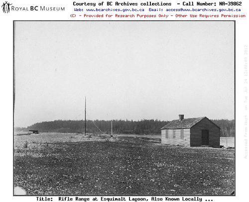
Perhaps the cannon on the far left of this BC Archives photograph (NA 39862, HP 008862), is the same one that was mounted ashore on the Coburg Peninsula, and fired by the Royal Navy in 1868.
Three slugs – identified as bullets from a Martini-Henry rifle – coincide with the rifles used by the Royal Navy and Royal Marines during the 1870s and to the 1890s. Also found were two Snider rifle bullets, indicating shooting activity, possibly as early as 1866 and prior to the Martini-Henry’s era. All the lead bullets were deformed from the impact of hitting the “butts”; they were uncovered no deeper than 4 inches in the swale.

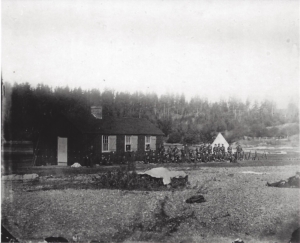
This Library and Archives Canada photograph (PA 124078), c. 1870, shows the Royal Navy at the Musketry Hut with rifles – most likely Martini-Henrys – “stacked” in military fashion. Popular rifle range shooting distances were 200, 500 and 600 yards.
In 1896, a house was built in line with the south-westerly shooting direction of the range, beyond the target location in the area north-east of “Sangster’s Knoll” and beyond the end of the spit. This was adjacent to a fresh water supply source used by the Royal Navy, and an abandoned cabin with an orchard. The British Admiralty then decided that, due to the capability of the new magazine-equipped rifles, errant rounds of volley fire would put the house and its residents in harm’s way. The Admiralty declined the option to purchase the land and house; instead, it made plans to build a new 1,000 yard rifle range on “Goose Spit” in Comox, and immediately closed the Coburg Peninsula range in 1897.
The house was likely in the area where a former Hudson’s Bay Company ship’s Captain from Glasgow, Scotland, James Sangster, had originally built his cabin. Sangster’s 20-acre farm property on Royal Bay was known as Lot 10, Section 7, Esquimalt District. Sangster died in October 1858, by his own hand. “Sangster’s Plains”, the former site of a gravel pit, was also named after him, as is the current Sangster School on Metchosin Road. Her Majesty’s sailors had erected a flume on the property in order that the water of the springs from which the Fleet was supplied with “Adam’s Ale” (a flowery term for pure, clear drinking water) could be readily accessed for obvious reasons, to “Quench a Sailor’s Thirst.”
Articles referred to here are “Naval Rifle Range” in the British Colonist of June 10, 1897, page 6; “Burglary at Sangster’s Plains,” also in the British Colonist, June 25, 1861, page 3; and The Maritime Museum of BC’s publication “The Bulletin” No. 28, March 1975.
Jack Bates of Victoria, B.C. has an abiding interest in researching, documenting and preserving the history of Esquimalt’s and Victoria’s military heritage.
To find out more about the history of Work Point, you can visit his website.
Articles
Hours
7 Days a Week: 10:00 am – 3:30 pm
Monday to Friday: 10:00 am – 3:30 pm
Hours
Monday to Friday: 8:00 am – 4:00 pm
To confirm if we are open, please call (250) 363-5655 or (250) 363-4312
Naval & Military Museum
Info@NavalAndMilitaryMuseum.org
CFB ESQUIMALT NAVAL & MILITARY MUSEUM
PO Box 17000 Stn Forces
Victoria, BC V9A 7N2